Thursday, May 28, 2015
Stay tuned
I am hitting the Sierra Nevada mountains soon. I cant wait to leave the desert sections. I'm tired of carrying water. There are many section between 25-30 miles of no water. I'm over it. Thanks for watching!!!!
Casa De Luna to Tehachapi
Hitched a ride to avoid the 25 mile road walk.

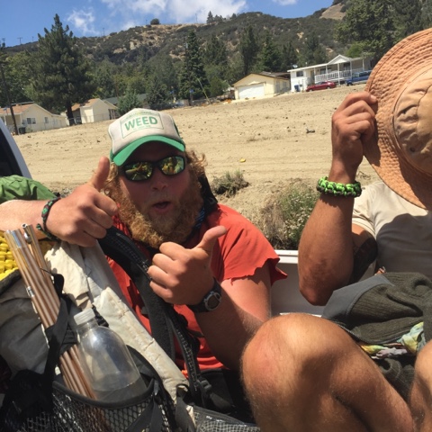
Love love love riding in the back of a pick up!

Dropped off at a "hostel". It's more like a dudes house with some couches in a garage. He let me drive his van down the road to a gas station and I thought I was going to die in that can. The brakes worked but it took a while.

Night hiked out of Hikertown.

The setting sun.

She thinks my tracker is sexy.

End of the road!!

And onto the L.A. Aquaduct.
 It eventually goes under ground to LA.
It's a sign. so you shoot it!

This road went on and on forever!!!

The moon was bright enough to hike without my light on. It was kinda freaky.

Cowboy camped on the Aquaduct.

Didn't like this section very much. No water and on a road forever!!!

Someone lives out here surprisingly and they left some soda and water bottles for us!!! Awesome!

It just kept going....

Forever and ever....

No water left for us.

This was a real treat!!!! Former thru hiker hated this section last year so mutch he came back here with a tent. And awesome tent!!!

Lots of hiker stayed here for a while to wait out the midday heat.

They had beer and food!!! And beer and food. It was more of a buffet.

One Step and Day Tripper paying thanks.

Some dirt bikers stopped by to see what was going on. There were bike trails everywhere.

Sad to see it but I had to happen. They were done for the weekend and were tearing it down.

Taking a siesta under a bridge.

It was up there. Took a nap to wait out the food coma.

The PCT goes through a huge wind farm in the Mojave. This was the small one. There were probably 5000 of these on the other side!!!

It's a sign. So you shoot it!!!

The wind farm.

Just a couple of lizards sun bathing.

I caught a Horney road!!!


 Huge resupply!!! Sending some of this to myself to places in the Sierras.

I think it was a girl. It did wink at me.
More windmills.
And more windmills!!!
The Tehachapi airport lets hiker camp here for $5.
Third time I've seen grass in a month!!!
Get to the choppa!!!!
There's more hikers!!! Some of these dudes stayed here for 4-5 days. Not sure why...
I've been craving ribs for a while and found a BBQ joint here!!! Mmmmmm
Huge resupply!!! Sending some of this to myself to places in the Sierras. Continentals breakfast of champs!!!
Wednesday, May 27, 2015
Big Bear Lake to Casa de Luna

Old PCT sign

On the ridge on the other side of Big Bear lake. There is still snow up on that mountain!!!

Remnants of a fire. I hike through a lot of this.

Always enjoy seeing water in the desert!!

I really liked this section! There were some trees still.

Water!!!!!

Dinner: couscous, sun dried tomatoes and salami. Mmmmmmmmmmmm

Other hiker next to a river. Sweet camp site!

Deep Creek. Nice fly fishing I'm told.

Deep Creek Hot Springs. There were about five or six natural hot tubs around here! So nice. It's a clothing optional hot spring.

Some locals having a good time down there.

I was really lucky here. This was a long section with no shade or water. About 15 miles. It was cloudy and windy so it wasn't too bad for me.

Hiking around an aqua duct.

I really wanted an action shot of a hiker falling in. Maybe next time.

Cold, cloudy and windy. A rain storm came through and up high there was snow.

Great hiking weather!

Small road walk to the trail.

Arrow lake.

Screen shot of a weather advisory.

Did 25 miles in rail, hail and 30 mph winds. This pretty girl stayed in a motel room with me. Her name is Mush.


She was exhausted too.
Mt. Baden-Powell. We stayed in town to dodge the foot of snow that fell on this one. It's named for the founder of the Boy Scouts.
Most of it melted and made the trail wet and slushy.
Baden-Powell summit.9,300 ft.
Former they hiker hiked up beer whiskey salami and cheese. I was there for two hours.
Higher than the clouds!!!!
Going down I was in the clouds.
Clouds baby!!!
The PCT was closed for about 10 miles for a endangered frog! Had to road walk around it.
Sun set on the road walk.

There I am!


Camping by a road. The next section had a bunch of Poodle Dog Bush every where. Made camping around it difficult. I guess it causes a nasty rash like poison oak.
Water cashe at a ranger station!!! Love it!!!

Hitching from Acton after a resupply. That's Pretzel.

I bounced my stove up so I'm not cooking dinners right now. That was lunch and dinner for 5 days.

Pretty dry out here.


Casa De Luna is a hippy daycare. It's at a trail angels house and they feed us and let you camp in the back yard. It was pretty awesome.
The front yard. Lots of hiker look forward to being here. A lot zero here. It's kinda a black hole of fun. I only stayed one night.
You're required to choose and wear a hawian shirt for your stay.
Pancakes and coffee for breakfast.


Subscribe to:
Posts (Atom)