Thanks for looking!
Thursday, June 11, 2015
Going for a hike
Getting back into the Sierra today. I'll be above 10,000 ft for the next 200ish miles. I'll be taking a side trail to Mt. Whitney, the highest point in the lower 48. It's around 14,508. And I'll go over the highest point on the PCT Forrestr pass.
Tehachapi to Lone Pine

Trail marker.

Didn't get back to the trail until 11am an it was 95 and miserable by 1:30. Had to take a 3 hour siesta. Edwards Air Force base is back there somewhere.

The water sources around here are few and far between. This one had frogs living in it. Delicious water from the spring though.

That's not a tan. Good ole fashion first. Everywhere.

The source was only 18 miles away!!! And it was a guzzler!

Water cache from a trail angel. Next natural water was in 36 miles. But there was a cache in between.

Drying my laundry at a motel. It was a cool 97 in the valley.

Me and the most interesting man in the world.

Kisses $1

More nasty desert. It never ends. It's hot dry and shitty.

Walked around this.

The guild said there was Uranium in the water. I still drank it. 4 liters and 2 Togo.

Lots of dead bugs. There was a bear bathing in this the day after I was here.

These two guys cowboy camped ever with the mosquitoes.

I slept very comfy in my tent. Mines the grey and orange one.

Starting to see some trees!!!

Siesta time. There was shade and a clear stream near by.

Some ate snacks while others slept.

More desert scrub.

Water!!! Moving water!!!!

Had to take a quick hiker bath in it!! Cold mountain run off.

Hiking through the meadow.

Kennedy Maxie's is the start of the Sierra Nevada mtns. Never tone get really excited to get this far.

Guard dog. Nice little fella.

KM is a vortex. I stayed here three days. Free camping, cheese burgers and beer. Lots of people get caught in the vortex and linger here for a week.

Hikers hanging out.

A monster cloud moved in one day.

And it finally rained in the high mountain desert!!! We played frisbee for a while in it.

A hiker doing his laundry.

Drink beers and playing chess.

On our way out.

All my stuff. I had to get a bear canister for the Sierra. I hate it!! I made my pack 2.5 lbs heavier and its bulky. I keep my sleeping bag in it.
 Back to the trail! And there are trees!!!!!
Back to the trail! And there are trees!!!!!
Glorious trees!!! I'm so happy to not be in the damn desert.

Water! Moving water!!!

Another hiker set his hat down on a ant pile. Hundreds of biting red ants. I was cracking up watching him deal with it.

Name that Author.
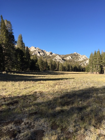
 Another huge meadow and a great view of the Sierra!!! Loving it.
Another huge meadow and a great view of the Sierra!!! Loving it.
I found a can of sardines in mustard sauce in an abandoned pack and had it on a tortilla with cheese and salami. Not recommended.

Hippy hiker doing yoga.

King of the meadow. Lord of the land. Master of mountains.

That's the meadow from earlier. I'm just 3,000 ft higher.

Rocks and trees!

Little guy was pooped. Needed a power nap.

That's a me!!!!

Hey look at that!
These meadows are around 10,000 ft!!!

The bear can pushed the metal stays in my pack into me. Had to reposition a few things and it worked out.

Found a hipbone. And lots of vertabre all day. This would make great battle mask!

Horseshoe meadow.

Still around 10-11,000 ft. It took me three hours to get a hitch 22 miles off the mountain. And it was raining.


Subscribe to:
Posts (Atom)